Drilling From The JOIDES Resolution Part 3
Drilling In Extreme Environments
|
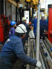
Photo courtesy of IODP. Rigging the downhole logging tools. |
What is considered to be an extreme environment for drilling? Sometimes it has to do with the temperature. For example, on one expedition to investigate superheated formations off the coast of Northern California, the borehole temperatures were around 175º C (375º F). Standard logging tools work in temperatures only as high as 160º (350º F). Specially designed tools are needed to drill in such a harsh environment.
Extreme conditions might also refer to the depth of the water. In offshore oil exploration terms, “deep water” usually means a depth of 1500 - 2100 m (5000 - 7000 ft). Sometimes the JOIDES Resolution drills in water even deeper than that. On one such voyage, an expedition to study seafloor formations near Costa Rica, the water was over 4800 m (16,000 ft) deep. The scientists used Schlumberger wireline tools, including logging-while-drilling (LWD) tools, to measure and assess the formations.
The wireline is an electrical cable that lowers wireline tools into the borehole. These tools measure the physical surroundings of the hole along with the depth and/or time at which the measurement is taken. The data is transmitted through the wireline to the ship where it becomes part of a record called a wireline log.
LWD tools are used to measure the properties of a formation either while the drilling is taking place or shortly thereafter. The sensors and electronics are built into a collar that is part of the drill bit assembly. Taking measurements at the same time as drilling isn’t easy, and it can be both risky and expensive. However, using LWD tools has some advantages. They may be able to take measurements in situations where regular wireline tools can’t. They also make it possible to take measurements before drilling fluids or debris enter the well, also called a borehole.
Determining Accurate Depths
The JOIDES Resolution is not only in the business of drilling holes. It also in collects and analyzes data.
|
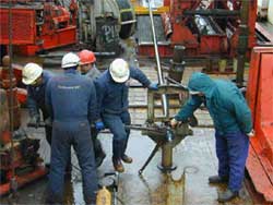
Photo courtesy of IODP. The drilling crew removes a new core from a core barrel that has just been raised to the surface. |
One of the most important sources of data is the core sample. Unlike typical oilfield drilling, the JOIDES Resolution takes core samples continuously, usually on every hole that it drills. The core shows the actual layers of rock material just as they exist beneath the sea.
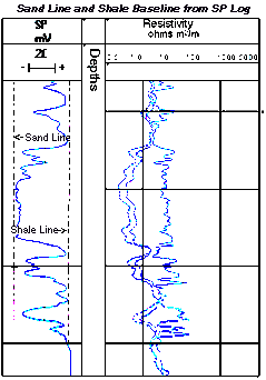
 As wireline or LWD devices take measurements inside the borehole, they send information to the ship in the form of another important source of data: the log. The log is like a long graph. The vertical (y) axis shows the depth. One of the wireline logging tools in use on the ship is a scanning tool that actually makes an image of the inside of the borehole. Depth accuracy is very important for this kind of measurement. It would not be of much use if the scientists did not know exactly where the image was taken. For example, it might be difficult to pinpoint where a sample came from because the surrounding area had undergone some significant geological changes such as when perhaps the rock layers were folded, uplifted, or otherwise disturbed by movements in the Earth’s crust. Scientists can compare the sample to the scanned logging image to find out exactly what part of the hole the core sample came from.
The horizontal (x) axis shows the response of the logging sensors to geological material on the outside edge of the borehole.
It is not easy to determine the depth of the borehole. The JOIDES Resolution stays in one spot horizontally because of her dynamic positioning system, but she is still subject to the motion of the seas. For the logged data to be of any real value, the depth measurement must be accurate to within a few centimeters (1 inch)—even in water more than 4.8 km (3 mi) deep! A special software program has been developed to meet this challenge. The program makes it possible to determine the depth accurately using data from the waves and several sensors on the ship itself to interpret measurements made by the logging tools.
|
Image courtesy of IODP. |
Together, the cores and the wireline/LWD log data give scientists a more complete picture of what is happening in the Earth’s subsurface. When the core sample is incomplete, or perhaps out of place in the hole, logging data can be used to determine the depth from which the uncertain sections were taken. It can also give some insight into the nature and cause of any missing core samples.
One example of the kind of interpretation possible took place on Leg 171b of the JOIDES Resolution. The objective was to study the theory that a large asteroid once struck the Yucatan Peninsula. According to the theory, the impact threw so much dust into the atmosphere that it changed the Earth’s climate. This dramatic climate change may explain the extinction of dinosaurs.
Evidence of the asteroid impact is suspected to be in a layer of sediment known as the KT boundary. This layer contains geologic elements that are typically found in asteroids. When the asteroid struck the earth, it would have cast tons of rock fragments and dust into the air. Inevitably some of the dust would have ended up on the ocean floor as sediment.
To test this theory, core samples were taken from several holes off the coast of Florida. Scientists analyzed the layers of sediment below the KT boundary. They found that the sediments were rich in the skeletal remains of tiny organisms. However, the layers of sediment immediately above the KT boundary showed very few such remains. This evidence suggests that millions of years of lifelessness followed the asteroid’s collision with the earth.
As you can see, the combination of core samples and log data offers a powerful interpretation tool for studying the earth’s geology and piecing together its mysteries.
Drilling Topics
 |
Riserless Drilling The Drilling Process |
 |
Heave Compensation Dynamic Positioning Wireline Logging |
 |
Specialized Equipment Drilling in Extreme Environments Determining Accurate Depths |
This content has been re-published with permission from SEED. Copyright © 2026 Schlumberger Excellence in Education Development (SEED), Inc.


